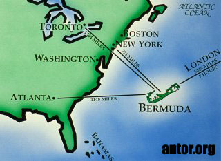
Pages

Monday, February 28, 2011

Bermuda


Map of Bermuda


Geography Bermuda
Location:
North America, group of islands in the North Atlantic Ocean, east of South Carolina (US)
Geographic coordinates:
32 20 N, 64 45 W
Map references:
North America
Area:
total: 53.3 sq km
land: 53.3 sq km
water: 0 sq km
Area - comparative:
about one-third the size of Washington, DC
Land boundaries:
0 km
Coastline:
103 km
Maritime claims:
territorial sea: 12 nm
exclusive fishing zone: 200 nm
Climate:
subtropical; mild, humid; gales, strong winds common in winter
Terrain:
low hills separated by fertile depressions
Elevation extremes:
lowest point: Atlantic Ocean 0 m
highest point: Town Hill 76 m
Natural resources:
limestone, pleasant climate fostering tourism
Land use:
arable land: 20%
permanent crops: 0%
other: 80% (55% developed, 45% rural/open space) (2001)

national animal(Humpback whale)

Angola


Map of Angola


Geography
Angola, more than three times the size of California, extends for more than 1,000 mi (1,609 km) along the South Atlantic in southwest Africa. The Democratic Republic of the Congo and the Republic of Congo are to the north and east, Zambia is to the east, and Namibia is to the south. A plateau averaging 6,000 ft (1,829 m) above sea level rises abruptly from the coastal lowlands. Nearly all the land is desert or savanna, with hardwood forests in the northeast.


National animal(Magnificent Frigatebird)


Sunday, February 27, 2011

Algeria

Map of Algeria

Geography
Nearly four times the size of Texas, Algeria is bordered on the west by Morocco and Western Sahara and on the east by Tunisia and Libya. The Mediterranean Sea is to the north, and to the south are Mauritania, Mali, and Niger. The Saharan region, which is 85% of the country, is almost completely uninhabited. The highest point is Mount Tahat in the Sahara, which rises 9,850 ft (3,000 m).


(national animal) Fennec Fox

Saturday, February 26, 2011

Latvia


Map of Latvia

Geography

Latvia borders Estonia in the north, Lithuania in the south, the Baltic Sea with the Gulf of Riga in the west, Russia in the east, and Belarus in the southeast. Latvia is largely a fertile lowland with numerous lakes and hills to the east.


Wagtail(national animal)

Lebanon

Map of Lebanon

Geography
Lebanon lies at the eastern end of the Mediterranean Sea, north of Israel and west of Syria. It is four-fifths the size of Connecticut. The Lebanon Mountains, which run parallel to the western coast, cover most of the country, while on the eastern border is the Anti-Lebanon range. Between the two lies the Bekaa Valley, the principal agricultural area.


Striped Hyena(national animal)


Lebanon

Wednesday, February 23, 2011

Namibia

Map of Namibia


Geography

Namibia is bordered on the north by Angola and Zambia, on the east by Botswana, and on the east and south by South Africa. It is for the most part a portion of the high plateau of southern Africa, with a general elevation of from 3,000 to 4,000 ft.

Oryx(national animal)

New Zealand


Map of New Zealand

Geography

New Zealand, about 1,250 mi (2,012 km) southeast of Australia, consists of two main islands and a number of smaller outlying islands so scattered that they range from the tropical to the antarctic. The country is the size of Colorado. New Zealand's two main components are the North Island and the South Island, separated by Cook Strait. The North Island (44,281 sq mi; 115,777 sq km) is 515 mi (829 km) long and volcanic in its south-central part. This area contains many hot springs and beautiful geysers. South Island (58,093 sq mi; 151,215 sq km) has the Southern Alps along its west coast, with Mount Cook (12,316 ft; 3754 m) the highest point. Other inhabited islands include Stewart Island, the Chatham Islands, and Great Barrier Island. The largest of the uninhabited outlying islands are the Auckland Islands (234 sq mi; 606 sq km), Campbell Island (44 sq mi; 114 sq km), the Antipodes Islands (24 sq mi; 62 sq km), and the Kermadec Islands (13 sq mi; 34 sq km).

Kiwi(national animal)

Tuesday, February 22, 2011

Kuwait


Geography

Kuwait is situated northeast of Saudi Arabia at the northern end of the Persian Gulf, south of Iraq. It is slightly larger than Hawaii. The low-lying desert land is mainly sandy and barren.


Camel(national animal)


Jorden


Geography

The Middle East kingdom of Jordan is bordered on the west by Israel and the Dead Sea, on the north by Syria, on the east by Iraq, and on the south by Saudi Arabia. It is comparable in size to Indiana. Arid hills and mountains make up most of the country. The southern section of the Jordan River flows through the country.


Oryx(national animal)


Oryx is one of four large antelope species of the genus Oryx. Three of the species are native to arid parts of Africa, with a fourth native to the Arabian Peninsula. Their pelage is pale with contrasing dark markings in the face and on the legs, and their long horns are almost straight. The exception is the Scimitar Oryx, which lacks dark markings on the legs, only has faint dark markings on the head, has an ochre neck, and horns that are clearly decurved.
The Arabian Oryx was only saved from extinction through a captive breeding program,[1] and the Scimitar Oryx, which probably now is extinct in the wild, also relies on a captive breeding program for its survival.[2] Small populations of several oryx species, such as the Scimitar Oryx, exist in Texas and New Mexico (USA) in wild game ranches. Gemsboks were released at the White Sands Missile Range and have become an invasive species of concern at the adjacent White Sands National Monument.


Sunday, February 20, 2011

Moldova


Geography

Moldova (formerly Moldavia) is a landlocked republic of hilly plains lying east of the Carpathian Mountains between the Prut and Dniester (Dnestr) rivers. The country is sandwiched between Romania and Ukraine. The region is very fertile, with rich black soil (chernozem) covering three-quarters of the territory.


Aurochs(national animal)

he aurochs or urus (Bos primigenius), the ancestor of domestic cattle, was a type of huge wild cattle which inhabited Europe, Asia and North Africa, but is now extinct; it survived in Europe until 1627. The aurochs was far larger than most modern domestic cattle with a shoulder height of 2 metres (6.6 ft) and weighing 1,000 kilograms (2,200 lb). The aurochs was regarded as a challenging quarry animal, contributing to its extinction. The last recorded aurochs, a female, died in 1627 in the Jaktorów Forest, Poland, and her skull is now the property of Livrustkammaren in Stockholm.


Malta


 Map of MALTA

 Geography

The five Maltese islands—Malta, Gozo, Comino, Comminotto, and Filflawith—have a combined land area smaller than Philadelphia. Malta is located in the Mediterranean Sea, about 60 mi (97 km) south of the southeast tip of Sicily.

Blue Rock-thrush(national  bird)


Pharaoh Hound(national animal)


Saturday, February 19, 2011

Spain

Map of Spain


Geography

Spain occupies 85% of the Iberian Peninsula, which it shares with Portugal, in southwest Europe. Africa is less than 10 mi (16 km) south at the Strait of Gibraltar. A broad central plateau slopes to the south and east, crossed by a series of mountain ranges and river valleys. Principal rivers are the Ebro in the northeast, the Tajo in the central region, and the Guadalquivir in the south. Off Spain's east coast in the Mediterranean are the Balearic Islands (1,936 sq mi; 5,014 sq km), the largest of which is Majorca. Sixty mi (97 km) west of Africa are the Canary Islands (2,808 sq mi; 7,273 sq km).


 Bull (national animal)


Red carnation, Pomegranate(national flower)


Germany


Map of Germany


Geography

Located in central Europe, Germany is made up of the North German Plain, the Central German Uplands (Mittelgebirge), and the Southern German Highlands. The Bavarian plateau in the southwest averages 1,600 ft (488 m) above sea level, but it reaches 9,721 ft (2,962 m) in the Zugspitze Mountains, the highest point in the country. Germany's major rivers are the Danube, the Elbe, the Oder, the Weser, and the Rhine. Germany is about the size of Montana.


Black Eagle (national bird)


Friday, February 18, 2011

France


 MAP of France

Geography

France is about 80% the size of Texas. In the Alps near the Italian and Swiss borders is western Europe's highest point—Mont Blanc (15,781 ft; 4,810 m). The forest-covered Vosges Mountains are in the northeast, and the Pyrénées are along the Spanish border. Except for extreme northern France, the country may be described as four river basins and a plateau. Three of the streams flow west—the Seine into the English Channel, the Loire into the Atlantic, and the Garonne into the Bay of Biscay. The Rhône flows south into the Mediterranean. For about 100 mi (161 km), the Rhine is France's eastern border. In the Mediterranean, about 115 mi (185 km) east-southeast of Nice, is the island of Corsica (3,367 sq mi; 8,721 sq km).


Gallic Rooster the national Bird of France


LILY IS NATIONAL FLOWER OF FRANCE


United Kingdom


 Map of U.k

Geography

The United Kingdom, consisting of Great Britain (England, Wales andScotland   ) and  Norhen Ierland is twice the size of New York State. England, in the southeast part of the British Isles, is separated from Scotland on the north by the granite Cheviot Hills; from them the Pennine chain of uplands extends south through the center of England, reaching its highest point in the Lake District in the northwest. To the west along the border of Wales—a land of steep hills and valleys—are the Cambrian Mountains, while the Cotswolds, a range of hills in Gloucestershire, extend into the surrounding shires.
Important rivers flowing into the North Sea are the Thames, Humber, Tees, and Tyne. In the west are the Severn and Wye, which empty into the Bristol Channel and are navigable, as are the Mersey and Ribble.
 London
THE LAKE DISTRICT
Eskdale


 THE Landon Eye

Scotland

About Edinburgh Castle

Edinburgh Castle is the number one visitor attraction in Scotland with over one million visitors every year. It's located at the heart of Scotland's Capital and the views of the City from its battlements are amazing.

 Eilean donan castle of scotland


 Northen IRELAND

National animals and Birds


Loin


Red deer


European Robin


Mute Swan


Red kites


Bulldog


Red Fox